Chart Your Course
Up a creek with a paddle…Follow from any of the launch locations. Enjoy a true rustic country paddle along Corney Creek as it spills into Lake D’Arbonne for a long 23.6 mile day paddle ending at Lester’s Marina or break up into smaller trips.
Compass Coordinates
Hwy 167 Launch 32.8878708/92.6569822 (start)
Barnes Bridge 32.8832/92.6012 (mile four)
La550Bridge 32.8565.92.573.9 (mile 12.6)
Lowery Ferry 32/8258.925492 (mile 12.6)
Persimmon Hole 32.8196/925228 (mile 14)
Hogpen Landing 32.8208/92/506 (mile 16)
Lester’s 32.7869 (mile 23.6)
Prospecting Treasure
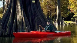
One of the most rustic scenic water trails and home to a myriad of wood ducks and the greenest-yellow foliage Spring-Summer! Corney is also one of the rare locations where pine trees border the waterway and because there are few houses/camps, you truly will experience nature here. From wild boars to deer, herons roost, turkey and owls, you will likely find wildlife!
Castaway Dangers
Portaging is possible in several places depending on water level. Creek splits offering more than one trail route and in high water, you may lose the channel often without a good gps tracker. During high water seasons, Corney Creek can offer some white-water excitement though as waters run fast around submerged and downed trees
Scouting History
Corney Creek begins in Arkansas, then reaches Corney Lake, part of Kisatchie National Forest in Claiborne Parish which is a feeder bayou to Lake D’Arbonne. It’s worth a day trip to drive to Corney Lake to see the dam where our creek begins. Although it has been up for debate, some say Corney (or Cornie as some bridges are engraved) is named for French mapmaker who charted the course from it’s Arkansas location.
Lies and Legends
In the 1970’s the Corney Creek Festival hosted an annual canoe race along this trail with hundreds attending annually. The canoe race followed the path from 167 and ended at the Hwy 550 bridge. It was part of the Governor’s Cup games held annually in the 1970’s through early 80’s.
