Chart Your Course
You really OTTER ta take this short day trip…From Hwy 2 Farmerville/Sterlington, turn left onto Wards Chapel Rd, Turn right at Antioch church, and immediate left behind church. Right on DeLoutre Ramp Rd.
Compass Coordinates
Launch: 32.7812/92.2604 at DeLoutre Road (behind Antioch Baptist Church). Here you can paddle left or right a few miles each way.
Prospecting Treasure
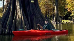
There is a geocache near the launch site. Launching left will take you past a few rope swings, past large beaver dams and a high cliff wall, right is more open & fisherman in boats, past a pasture with cows, and here is where we saw a bear swimming once! The DeLoutre is unique because of the dark rich soil and the leaf tannins that make the waterway dark black in some places. In the Fall, the colorful leaves blanket the bayou against the black water for the most scenic trail you’ll find anywhere around!
Castaway Dangers
Portaging and overhanging trees likely depending on water level. Watersnakes (mostly non venomous) and gators are commonly seen.
Scouting History
Bayou DeLoutre was named by early French explorers who wrote in early journals that the waterway was “teaming with otters”. Reclusive otters are still here today although seeing them is a rare sighting.
Lies and Legends
Look for mayhaws along this trail. Marion is known for its unique mayhaw jelly & festival first weekend in May. Bayou DeLoutre is listed as a Louisiana Wild & Scenic River Stream.
